
explore...experience...extreme adventures...discover Philippines Islands
THE ISLAND OF BOHOL
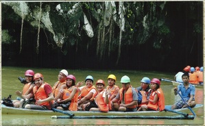
Bohol, in the heart of Central Visayas, is 10th largest island in the country. Approx. 803km South of Manila and 79 km southeast of Cebu. Bohol is the ECO-CULTURAL TOURIST destination of the new millennium. An oval-shaped island dotted with 72 small islets comprising an area of 4,117 sq. km. it has 47 towns and the capital city is Tagbilaran.
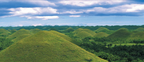
Origin of the name: BOHOL, derived from the word Bo-ho or Bo-ol, is the seat of the first international treaty of peace and unity between Datu Sikatuna, a native chieftain and Miguel Lopez de Legaspi, a Spanish conquistador on March 16, 1565 through a blood compact known today as SANDUGO. Bohol God’s Little Paradise, as it is sometimes called by the Boholano’s themselves. This is not fully unjustified, as the island, is one of the most diverse and attractive destination in the Philippines. It houses countless white sandy beaches, numerous historic churches and watchtowers, enchanting waterfalls and caves, and unique in the world, its amazing and stunning Chocolate Hills. The people of Bohol were warmth and dignity, making this Southern Province the destination of choice local and foreign tourists.
AURORA TRAVEL & TOURS Offers online reservation of hotels and resorts accommodation, meals, transportation service, tour packages or just the basic bed and breakfast package. Specializing in tailoring private tours and excursions for small or big groups of families, corporate and individual to accommodate your valued holiday schedule and interest, we can help you plan itinerary.
Our spirit is to promote through adapted and personalized tourist products the values of the natural, historical and cultural wonders, inspires superlatives and impresses everyone with rich and diverse experience.
The Island-Province of Bohol
Bohol is the 10th largest island in the country, nestled securely at the heart of the Visayas, between southeast of Cebu and Southwest of Leyte. Bohol is the Heritage Province, where the environment and the life in the countryside are still closer to the traditional image. As we have noticed, tourists have a growing interest for visiting Bohol. We are mainly interested in promoting the ecological-cultural tourism, which keeps tourist far from the stress of towns, allowing active vacations, but also sight-seeing and human contacts, shoreline is covered with fine, white sand and its pristine azure waters never fail to entice visitors to take a dip, all this for correct prices and good services, very well appreciated by the guests. The few resorts and hotels we are working with have good standards of quality.
Getting to Bohol
From Manila : Domestic carriers such as Philippine Airlines, Cebu Pacific, Zest Air
Airphil Express have direct flights to Tagbilaran City daily with 1hour travel time.
From Cebu : Fast Craft sea vessels such as Ocean Jet Ferry, SuperCat and Weesam Express
have daily trips to Tagbilaran City with approximately 1hour and 45 minutes travel time.
Feel free to contact us if you have any proposals concerning the duration of the journey, the period of accommodation, the meals, the transportation, the specific thematic programs for groups and other special interest in Cebu.
Email your inquiry to [email protected] or [email protected]
THE ISLAND OF CEBU
The Island of revelry -Cebu City Often called the “Queen City of the South” and the Seat of Christianity in the Philippines , Cebu is the country's oldest city. Exploring Cebu City, one encounters a rich historic past. Cebuano’s are extremely proud of their cultural and historical heritage, a legacy which has endured through the centuries from the time the great explorer Ferdinand Magellan first planted the cross on Cebu’s shore. Time has been kind to Cebu.
From Zubu, the busy trading port in 1521, it has evolved into a highly urbanized metropolitan center which now serves as focal point of growth and development in Southern Philippines.
With its 6 cities; Cebu, Danao, Lapu-Lapu, Mandaue, Toledo and Talisay; and its 47 smaller towns, Cebu has more than kept pace with the nation's progress. Today the island province leads in traditional and non-traditional exports and has the highest economic growth rate anywhere in the country. Likewise, recent indications pointed out that Cebu has become the country's favorite tourist destination. In contrast to the bustling metropolis, the rest of Cebu’s 167 islets and islands are lined with idyllic white sandy beaches and pristine clear waters. Cebu has gained wide popularity for fantastic diving grounds evidenced by the proliferation of resorts which offer luxurious accommodations, excellent dive facilities and the services of competent dive masters and dive guides. Cebu’s strategic location makes it ideal for those who wish to travel to the other islands and provinces by plan, boat or bus. No place could be too far from Cebu.
How to get to Cebu By Air
Travelers from abroad may fly to Mactan-Cebu International Airport. Among the national carriers from Manila direct flights to Cebu are: Cebu Pacific Airlines, Philippine Airlines, Zest Air, Airphil Express are the most common airplanes that land in Mactan Airport. Among the international carriers, Silk Air arrives from Singapore.
From Hong Kong, the frequent carriers landing in the airport are Cathay Pacific and Cebu Pacific. Qatar Airways has a direct connection to Mactan Airport from the Middle East country.
How to get to Cebu By Sea
The Super Ferry is one of the more comfortable means of transportation from Manila to Cebu. Cabin reservations can be arranged by those who are planning to bring along their friends or families. The Quadruple Cabin sharing has its own toilet and bath. The trip normally takes about a day. There are daily trips with the exception of Saturday. Fast Craft Ferries from Bohol, Dumaguete, Camiguin has daily schedules.
How to get to Cebu By Land
Taking the bus is the best option when travelling from one end of Cebu to another. This can be done by taking a ride from the north or south terminal. Jeepneys provide the mode of transportation when going for a city trip. This gives tourists the chance to meet local people. Likewise, there is the tartanilla, which are horse-drawn carts, that give tourists the chance to experience the lives of early Cebuanos.
Feel free to contact us if you have any proposals concerning the duration of the journey, the period of accommodation, the meals, the transportation, the specific thematic programs for groups and other special interest in Cebu.
Email your inquiry to us at [email protected]
THE ISLAND OF CAMIGUIN
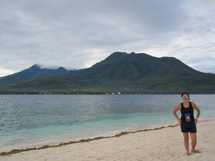
Camiguin Island – is located only 10 km north of Mindanao and is well known as a natural paradise. From the north side of the island you can see the Island of Bohol, which is about 50 km away.
There are Seven(!) Volcanoes on the island itself from which two are still considered "active".
The presence of these volcanoes which rise up to 1800 meters high, supply the island with lots of water which comes out from several hot and cold springs all over the island. Rivers are forming waterfalls, where the water drops down from up to 76 meters in the middle of a tropical rainforest, like the Katibawasan Falls. Since Camiguin is an volcanic island, most of its beaches are black. Maybe the only drawback, at least if you like white beaches on an tropical island. But if you like to see white beaches, you might take a short boat trip to White Sand or to Mantigue Island and you have white beaches at it's best. Camiguin does not only have natural wonders on the surface. The beauty of the island continues even under water and offers some very spectacular and colorfull dive sites. Turtles, Manta Rays and Reef Sharks can be seen at the right time of the year. Taken all this natural wonders in consideration, you should think that the island would be occupied with tourists but only a very few resorts gather for the very few foreign tourists who come to Camiguin every year. For tourists that means that the local people are not spoiled by tourist money and there is no typical tourist ripp off on the island. The locals are very friendly to foreigners and will always greet you with "Hello Friend" unlike the typical "Hello Joe" which you will hear at every other place in the Philippines.
Spending your holiday in Camiguin means quiet and peacefull holidays. Just enjoy the natural beauty of the island and relax. If you feel bored however, just sign up for some Scuba Diving or a trekking tour to the Hibok Hibok Volcano. You may also want to rent a motorbike and discover some of the waterfalls and springs by yourself.
Getting to Camiguin Island
It might be a little difficult sometimes to travel to Camiguin. The only direct and daily connection by boat is to Cagayan de Oro and Balinguan on the main Island of Mindanao and to Jagna on Bohol Island. Once a week , a ferry boat also goes from Cebu to Camiguin.
There used to be three weekly flights by SEAIR from Cebu as well but all flights has been suspended recently for some unknown reason.
From Cagayan de Oro to Camiguin:
Daily Fast Craft (Paras Sea Cat) departs at the Port of CDO at 8:30 am and arrives in Benoni on Camiguin at 10:30 am. Alternatively, take a bus or van from Agora Bus Terminal to Balinguan (about 2 hours, 80 km). Busses depart at the terminal every hour or so.
It might be easier and more comfortable to take a taxi from town or at the airport that will bring you directly to Balinguan in about 1 1/2 hours. The Price for the taxi should be around 1000, - Peso.
From Balinguan to Benoni on Camiguin, small ferries depart about every hour.
From Manila :
Take a flight to Cagayan de Oro and follow the instructions above.
From Cebu:
A Super Shuttle Ferry departs every Friday at 8:00 pm from Pier 8 in Cebu and arrives at Balbagon Port on Camiguin the next morning at about 7:00 am.
It sails back on Sunday evening 8:00 pm.
(Ask at the Pier for the exact schedule, it might be changed slightly from time to time.)
On other days of the week, the only ways to get from Cebu to Camiguin is via Cagayan de Oro or Jagna on Bohol Island.
From Cebu to Cagayan de Oro you can either travel by boat or by plane. Use the method described above to get from CDO to Camiguin.
If you prefer to travel via Bohol, take a Fast Craft to Tagbilaran in Bohol (1 1/2 hours) and from there a taxi, van or Jeepney to Jagna, which takes another 1 to 1 1/2 hours. Please be aware that you have to arrive in Jagna before 1:00 pm to catch the daily ferry boat to Camiguin. The price for the ferry boat is 400, - Peso.
OCEANJET FAST CRAFT FERRY travels from Jagna (Bohol) to Benoni on Camiguin every Tuesday to Sunday at 1:30 pm. The schedule from Camiguin to Jagna (Bohol) is 10:00 am on the same days.
Feel free to contact us if you have any proposals concerning the duration of the journey, the period of accommodation, the meals, the transportation, the specific thematic programs for groups and other special interest in Camiguin.
Email your inquiry to [email protected]
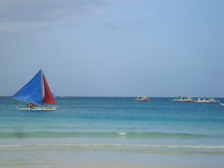
THE BORACAY ISLAND
About Boracay
The first settlers of Boracay in Panay are called Negritos or Atis. Panay are then called "Land of the Atis" These Negritos are the indeginuous people of the Philippines and they farmed and fished in Boracay for centuries.
During the 1940s and 1950s, the Boracaynons or the people of boracay, depended largely on fishing and coconut plantation. Copra, the dried meat of coconut, was traded to businessmen from Aklan in exchange for rice and other goods and commodities. During the 1960s and 1970s, Boracay became popular among families from Panay.
When a German writer published a book about the Philippines in 1978, describing boracay history and the beautiful island in details, the island was introduced to the world. This mark the beginning of tourist "boom" with tourist. Since then, The onset of tourism changed Boracay completely. As word of its exceptional beauty--specifically the immaculate white sands of White Beach spread, tourists began arriving.
Suddenly, from a sleepy, sparsely populated island, Boracay was transformed into a major destination on the international travel circuit. Whether the change was for the better or worse is an open question, but it was certainly a turning point in the history of Boracay Island.
Getting to Boracay
By Plane
The most popular means of travelling to boracay in Malay, Aklan is by air via Kalibo. There are regular cheap flights from Manila to Kalibo Airport in Aklan on Panay Island. The flight takes less than one hour, but an additional 90 minutes bus trip to Caticlan Jetty Port is required.
From Kalibo to Caticlan
Southwest Tours, Star Express and 7107 Island Tours ply the route from Kalibo Airport to Caticlan with air-conditioned buses or coasters. Included in the price is also the boat transfer from Caticlan to one of Boracay's boat stations. Other means of reaching Caticlan are mini-vans, which are a little cheaper, but don't provide boat service to Boracay. The trip takes 1 to 1.5 hours.
Smaller turbo planes fly directly to Caticlan Airport, This is the fastest way and from Caticlan Airport, only a short tricycle ride to the jetty port.
By Ship
An adventorous but more leisurely and romantic way to travel to Boracay is by Ferry from Manila to Caticlan or Dumaguit, near Kalibo. The trip to Boracay takes about 17 hours.
MBRS Shipping Lines have two boats plying the route from Manila to Caticlan. The ships leave Manila's North Harbor, Pier 8, every Friday, Monday and Wednesday and arrive in Caticlan the next day.
Other shipping companies service the route Manila to Dumaguit, half an hour east from Kalibo. The companies are WG&A and Negros Navigation.
By Land
Caticlan, the entry point for Boracay, can be reached also by private cars or air-conditioned buses, via the 'strong republic nautical highway', stretching from Batangas, Luzon, to Cagayan de Oro. This is probably the cheapest way to go to Boracay. But it takes more time an adventorous spirit. Travel to Boracay by Roro.
Arriving on Boracay - The new Jetty Port at Caticlan
Boracay Island itself is then reached by travelling on motorized bancas (motorized outtrigger boats), which is continously ply the short trail between the island. The boat trip takes 20 to 25 minutes and land at three defined areas, known as Boat Stations 1,2 and 3 along the shoreline of White Beach. If you're going to visit Boracay, it is advisable that you find out in advance which Boat Station is closest to the resort where you are staying. Most travel agency can arranged that for you.
TIP: it is best to wear casual clothes like shorts, T-shirt and slippers for arrival and departure boat trips. You may get wet while crossing the channel between Caticlan and Boracay Island, and usually one has to wade a short distance in shallow water from the boat to the beach.
Feel free to contact us if you have any proposals concerning the duration of the journey, the period of accommodation, the meals, the transportation, the specific thematic programs for groups and other special interest in Boracay.
Email your inquiry to us at [email protected]
THE PALAWAN GROUP OF ISLAND
About Palawan
The name “Palawan” – most probably - was given by the Chinese as far back as the 9th Century. They called it PA-LAO-YU, or “land of beautiful safe harbour”. Others believe it came from the Indian word “Palawans” meaning “Territory”. The popular believe is that “Palawan” is a corrupted form of the Spanish word “Para agua” because the main island’s shape resembles a closed umbrella.The limits of the Province are :
Busuanga island in the north
Agutaya group of islands northeast
Cagayancillo (who has not heard about Tubattaha Reef) in the east
Balabac island in the south
Spratly - Kalayaan in the West
Did you know that Palawan is made up of 1768 islands and is the second largest province of the Philippines (Cotabato is the largest) ? The length of the main island is 425km from tip to tip. The distance between extreme north and south of the island province is 650 km. The narrowest section of the main island is 8.5 km at Barrio Bahile in Puerto Princesa, the widest section is 40 km at Brooke's’Point in the south. During the drive to the Resort, which will take 90 minutes, you will see that a chain of tall mountain ranges runs through the entire length of the island, dividing it into two distinct areas called the east coast and the west coast. Princessa Holiday Resort is on the east coast facing the Sulu Sea.
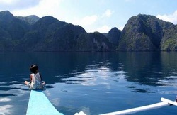
Palawan Islands
Palawan is one of the Last Unexplored Islands in the Pacific, as well as the location of the 1997 James Bond thriller "Tomorrow Never Dies." Jacques Cousteau remarked that Palawan was the most beautiful place he ever explored. Renowned underwater explorer Jacques Costeau has described Palawan as having one of the most Beautiful Seascapes in the world. Sprawled beneath the seas are nearly 11,000 square kilometers of coral reefs. Myriads of fish swim in these underwater gardens.
Home of Lofty Mountains, Rainforests, and the World's Longest Underground River, Palawan is nestled between Mindoro island and North Borneo. Palawan is nestled between Mindoro island and North Borneo. Palawan is the Philippine Largest Province, covering 1.5 million hectares. Palawan Rainforests extend to the Seashore... Miles upon miles of White Sandy Beaches...Crystal clear water that Abound with Multi-Colored fish and Corals in its sea floor.. Awe-Inspiring natural Scenic Wonders.. Palawan Historical and Archeological Treasures. Its Thousands of Islands and Islets are the home of various Tropical Flora, Fauna, Various Palawan Orchid species and Palawan Cherry Blossoms. Palawan is the home of Palawan Monkeys, Palawan Parrots, Palawan Bear cats, Palawan Peacock, Mongoose, Scaly AntEater, Porcupine, and mouse deer. The presence of Palawan 323 species of Wild Life in Palawan, gained the Province the title "HAVEN of the PHILIPPINE WILDLIFE".
Known the world over as the Philippines last ecological frontier, the province of Palawan harbor vast tracts of tropical rainforest and a huge expanse of marine wilderness. Thick canopies of trees carpet mountain ranges running the length of the mainland. Fringing reefs and coral atolls open a new realm to discover under the clear waters sorrounding this archipelago of more than 1,700 plus Tropical Islands. Ribbons of meandering streams and rivers wind through the mountains, nurturing robust stands of mangrove in the lowlands before flowing out to the sea.
Palawan probably has more protected areas than any other province in the Philippines. The Calauit Wildlife Sanctuary in the northern Calamianes islands is home to exotic and endemic species of animals that roam freely in its verdant hills and plains. On the northern coastline, the El Nido Marine Reserve is noted for its edible birds’ nests and limestone cliffs. In the middle of the Sulu Sea lies the Tubbataha reefs, a pair of coral atolls recently named as a World Heritage Site for its highly diverse collection of fishes and other marine life. Along the west coast, the St. Paul Subterranean National Park features old-growth forests, cathedral caves, white sand beaches, and one of the longest underground rivers in the world. In the South, Ursula Island is a haven for migratory and resident birds.
The entire province was proclaimed as Fish and Wildlife Sanctuary in 1967. Palawan is the habitat of 232 endemic species. Some of these unique creatures are the metallic-colored peacock pheasant, the shy mousedeer, the cuddly bearcat, and the reclusive scaly anteeater. In the forests and grasslands, the air resonates with the songs of more than 200 kinds of birds. Over 600 species of butterflies flutter around the mountains and fields of Palawan, attracted to some 1,500 flowering plants found here. Endangered sea turtles nest on white sand beaches, and the gentle dugong feeds on the seagrass that abound in Palawan’s Waters.
Commercial logging became a thing of the past with the cancellation of timber license agreements in 1993. That same year, the provincial government created a Bantay Palawan to assist national agencies in protecting some 325,000 hectares of primary forest. Residual and mossy forests cover an additional 26,000 hectares of Palawan’s land area.
Rocky coves and sandy beaches lie in primordial splendor along Palawan’s almost 2,000-Kilometer coastline. Renowned underwater explorer Jacques Costeau has described Palawan as having one of the most beautiful seascapes in the world. Sprawled beneath the seas are nearly 11,000 square kilometers of coral reefs. Myriads of fish swim in these underwater gardens.
Outstanding geographical features dot Palawan’s landscape. On the west coast, an array of limestome cliffs extends from Tabon Caves in the south all the way to Coron Reefs in the northern Calamianes islands. Challenging peaks with mystical names like Matalingahanan, Cleopatra’s needle, and Capuas attract dozens of climbers yearly.
Getting to Palawan
Palawan can be reached within an hour and five minutes' flight from Manila to the capital city of Puerto Princesa or a 20-hour trip by sea. A choice of regular Philippine Airlines (PAL) or direct chartered flight can be made depending on the desired destination.
PAL flights will take one directly to the heart of the province where connecting trips to nearby premier sites can be made.
Charter flights via Soriano Air or Pacific will take one to the Island of desire, be this Cuyo, Curon, Busuanga, or El Nido.
WG & A Shipping Company plies the Manila-Palawan routes regularly.
Feel free to contact us if you have any proposals concerning the duration of the journey, the period of accommodation, the meals, the transportation, the specific thematic programs for groups and other special interest in Palawan.
Email your inquiry to [email protected].
The name “Palawan” – most probably - was given by the Chinese as far back as the 9th Century. They called it PA-LAO-YU, or “land of beautiful safe harbour”. Others believe it came from the Indian word “Palawans” meaning “Territory”. The popular believe is that “Palawan” is a corrupted form of the Spanish word “Para agua” because the main island’s shape resembles a closed umbrella.The limits of the Province are :
Busuanga island in the north
Agutaya group of islands northeast
Cagayancillo (who has not heard about Tubattaha Reef) in the east
Balabac island in the south
Spratly - Kalayaan in the West
Did you know that Palawan is made up of 1768 islands and is the second largest province of the Philippines (Cotabato is the largest) ? The length of the main island is 425km from tip to tip. The distance between extreme north and south of the island province is 650 km. The narrowest section of the main island is 8.5 km at Barrio Bahile in Puerto Princesa, the widest section is 40 km at Brooke's’Point in the south. During the drive to the Resort, which will take 90 minutes, you will see that a chain of tall mountain ranges runs through the entire length of the island, dividing it into two distinct areas called the east coast and the west coast. Princessa Holiday Resort is on the east coast facing the Sulu Sea.
Palawan Islands
Palawan is one of the Last Unexplored Islands in the Pacific, as well as the location of the 1997 James Bond thriller "Tomorrow Never Dies." Jacques Cousteau remarked that Palawan was the most beautiful place he ever explored. Renowned underwater explorer Jacques Costeau has described Palawan as having one of the most Beautiful Seascapes in the world. Sprawled beneath the seas are nearly 11,000 square kilometers of coral reefs. Myriads of fish swim in these underwater gardens.
Home of Lofty Mountains, Rainforests, and the World's Longest Underground River, Palawan is nestled between Mindoro island and North Borneo. Palawan is nestled between Mindoro island and North Borneo. Palawan is the Philippine Largest Province, covering 1.5 million hectares. Palawan Rainforests extend to the Seashore... Miles upon miles of White Sandy Beaches...Crystal clear water that Abound with Multi-Colored fish and Corals in its sea floor.. Awe-Inspiring natural Scenic Wonders.. Palawan Historical and Archeological Treasures. Its Thousands of Islands and Islets are the home of various Tropical Flora, Fauna, Various Palawan Orchid species and Palawan Cherry Blossoms. Palawan is the home of Palawan Monkeys, Palawan Parrots, Palawan Bear cats, Palawan Peacock, Mongoose, Scaly AntEater, Porcupine, and mouse deer. The presence of Palawan 323 species of Wild Life in Palawan, gained the Province the title "HAVEN of the PHILIPPINE WILDLIFE".
Known the world over as the Philippines last ecological frontier, the province of Palawan harbor vast tracts of tropical rainforest and a huge expanse of marine wilderness. Thick canopies of trees carpet mountain ranges running the length of the mainland. Fringing reefs and coral atolls open a new realm to discover under the clear waters sorrounding this archipelago of more than 1,700 plus Tropical Islands. Ribbons of meandering streams and rivers wind through the mountains, nurturing robust stands of mangrove in the lowlands before flowing out to the sea.
Palawan probably has more protected areas than any other province in the Philippines. The Calauit Wildlife Sanctuary in the northern Calamianes islands is home to exotic and endemic species of animals that roam freely in its verdant hills and plains. On the northern coastline, the El Nido Marine Reserve is noted for its edible birds’ nests and limestone cliffs. In the middle of the Sulu Sea lies the Tubbataha reefs, a pair of coral atolls recently named as a World Heritage Site for its highly diverse collection of fishes and other marine life. Along the west coast, the St. Paul Subterranean National Park features old-growth forests, cathedral caves, white sand beaches, and one of the longest underground rivers in the world. In the South, Ursula Island is a haven for migratory and resident birds.
The entire province was proclaimed as Fish and Wildlife Sanctuary in 1967. Palawan is the habitat of 232 endemic species. Some of these unique creatures are the metallic-colored peacock pheasant, the shy mousedeer, the cuddly bearcat, and the reclusive scaly anteeater. In the forests and grasslands, the air resonates with the songs of more than 200 kinds of birds. Over 600 species of butterflies flutter around the mountains and fields of Palawan, attracted to some 1,500 flowering plants found here. Endangered sea turtles nest on white sand beaches, and the gentle dugong feeds on the seagrass that abound in Palawan’s Waters.
Commercial logging became a thing of the past with the cancellation of timber license agreements in 1993. That same year, the provincial government created a Bantay Palawan to assist national agencies in protecting some 325,000 hectares of primary forest. Residual and mossy forests cover an additional 26,000 hectares of Palawan’s land area.
Rocky coves and sandy beaches lie in primordial splendor along Palawan’s almost 2,000-Kilometer coastline. Renowned underwater explorer Jacques Costeau has described Palawan as having one of the most beautiful seascapes in the world. Sprawled beneath the seas are nearly 11,000 square kilometers of coral reefs. Myriads of fish swim in these underwater gardens.
Outstanding geographical features dot Palawan’s landscape. On the west coast, an array of limestome cliffs extends from Tabon Caves in the south all the way to Coron Reefs in the northern Calamianes islands. Challenging peaks with mystical names like Matalingahanan, Cleopatra’s needle, and Capuas attract dozens of climbers yearly.
Getting to Palawan
Palawan can be reached within an hour and five minutes' flight from Manila to the capital city of Puerto Princesa or a 20-hour trip by sea. A choice of regular Philippine Airlines (PAL) or direct chartered flight can be made depending on the desired destination.
PAL flights will take one directly to the heart of the province where connecting trips to nearby premier sites can be made.
Charter flights via Soriano Air or Pacific will take one to the Island of desire, be this Cuyo, Curon, Busuanga, or El Nido.
WG & A Shipping Company plies the Manila-Palawan routes regularly.
Feel free to contact us if you have any proposals concerning the duration of the journey, the period of accommodation, the meals, the transportation, the specific thematic programs for groups and other special interest in Palawan.
Email your inquiry to [email protected].
The Calamian Group of Island
CORON TOWN
Location and Geography
Coron is one of the 4 municipalities in the Calamian Group of Islands and is the northernmost municipality of Palawan, on the Philippines' southwestern border. It is halfway both from Manila and Puerto Princesa (the capital city of the Province of Palawan).
It is said that the bay of Coron looks like an earthen pot. Coron is the term for pot in local dialect.
HISTORICAL BACKGROUND
The first inhabitants of Coron were the Tagbanuas who belong to the second wave of Indonesians who migrated to this country some 5,000 years ago. They are nomadic and sea-faring people, living mainly by fishing and crude agriculture or "KAINGIN FARMING" in the local dialect. To this day, although they have learned to live in an organized settlement, they remain primitive as they are greatly influenced by their old customs, traditions and superstitious beliefs. Today, the Tagbanuas are the natives of CORON. It was in 1902 that Coron was registered as a town and the name of the town was officially changed from Penon de Coron to CORON.
From 1939 to the outbreak of World War II, the municipality experienced the mining boom. Labor shifted from farming to mining. In July 1942, the Japanese occupied mining camps and resumed operation of the manganese mines. On September 24, 1944, several Japanese ships were sunk by American warplanes at Coron waters as they retreat from Manila Bay. To this day, 12 of these World War II Japanese shipwrecks make-up what is considered as one of the best dive sites in the world.
In 1947, large scale deep sea fishing was introduced and operated in Coron. The town experienced another boom, a fishing boom. The population increased. Many people from Luzon and Visayas came to work either as fishermen or miners.
On June 17, 1950, Busuanga was officially created as a separate municipality from Coron and in 1954, Coron was further reduced by the official creation of the Municipality of Linapacan. On September 12, 1992, Coron was finally reduced by the official creation of the Municipality of Culion.
Today, the municipality of Coron itself is composed of CORON ISLANDS, a portion of Busuanga Island, and more than 20 other outlying Islands.
Its breathtaking limestone cliffs, crystal-clear turquoise-colored waters with pristine white, powdery-sand beaches are just but a few that attract tourists like magnets.
The rugged, unspoiled countryside contributes to the charm and unparalleled landscape of the whole area. Other interesting spots worth visiting are the hotsprings, volcanic lakes, 500 caves and a thriving marine population.
PEOPLE AND LANGUAGE
The population is around 40,000, made-up of indigenous Tagbanuas, Cuyonens (the locals of Coron) and a mixture of other settlers from other provinces.
FILIPINO (Tagalog) is the predominantly spoken language. CUYUNON is the indigenous spoken dialect in the whole of Palawan but the Tagbanuas speak their native tongue, "TINAGBANWA". The settlers speak their home dialects such as VISAYA, ILOCANO and ILONGGO. Large percentage of the population is able to communicate in English.
PREMIER TOURIST ATTRACTIONS
CORON ISLANDS - surrounded by majestic limestone cliffs, with torquise lakes and several lagoons and coves where one can navigate around by kayak. It is a stretch of mountains made-up of limestone fronting the Coron town. Accessible by motorized banca from town in 20minutes ride.
LAKES WITHIN CORON ISLANDS
KAYANGAN LAKE - located within the heart of Coron Islands, it has been adjudged as the country's cleanest inland lake for 5 consecutive years making it to the HALL OF FAME. The crystal-clear waters is inviting for a swim. To get there, you have to trek the trail going-up the lake for about 30 minutes which offers magnificent postcard-perfect view. The entrance itself is awe inspiring and mesmerizing!
BARRACUDA LAKE - the trek is shorter but more challenging, with deeper waters than Kayangan. Its attraction is in the thermal layers; water gets hotter as you go down the lake. It is said that there is a resident Barracuda within the lake hence the name. Great for diving.
LAGOON WITHIN CORON ISLANDS
TWIN LAGOONS - from one lagoon to the other, there is an underwater tunnel making it an adventure to swim and cross the opening. Limestone cliffs separate the two lagoons.
BEACHES WITHIN CORON ISLANDS
BANOL BEACH - made-up of 2 beaches, the BIG BANOL and the SMALL BANOL with spectacular rock formations. It is the nearest beach from town with fine, powdery white sand.
ATUAYAN BEACH or KATUAYAN - Meaning full of shells in the native tongue, has a very long stretch of beach with calm seas, ideal for snorkeling and kayaking. There is a lake at the back of the beach which can be reached by climbing the cliff.
SKELETON WRECK - also known as Malwawey Island- it has a small beach with nice coral reef and small ship wreck. ...AND still, there are other lakes and a number of beaches in Coron Islands which are home to the natives, the
Tagbanuas; they are the indigenous people of Palawan. Considered though, as their ancestral domain, they do not allow the public to have access on these areas.
OTHER TOURIST SPOTS/DESTINATIONS OUTSIDE OF CORON ISLANDS;
MAQUINIT HOT SPRINGS - said to be therapeutic and medicinal, its hot waters with 38-42 degrees Celcius temperature is a real treat to its visitors especially after a day's swim in the beaches. Its waters are salty and the algae growing on the walls of the pool is said to contain "SPIRULINA", setting it apart from the other hotsprings around the archipelago.
SIETE PECADOS MARINE PARK - Home to a rich marine life, with
abundant corals, it is a cluster of 7 small islands very near Maquinit Hot Springs, ideal for snorkeling.
LUSONG GUNBOAT WRECK - One of the World War II Japanese vessels, which sank in Coron waters, its location under the sea is shallow enough making it visible by the naked eye even without scuba diving in it.
MALBATO MARINE PROTECTED AREA - Mangrove forests, seagrass beds, and coral reefs make this an excellent area for mangrove paddle tours.
BINTUAN-SANGAT MARINE PARK - This is another great spot for snorkeling and kayaking.
CALAUIT ISLAND WILDLIFE SANCTUARY - Home to giraffes, zebras, Calamian Deers, Mouse Deers (smallest deers in the world), bear cats and other rare species, the sanctuary was established in l970's. Via the park's truck, visitors can tour the island where one can observe the animals in their natural habitat. One can even feed the giraffes on bare hands. By banca, visitors should leave town before dawn to reach Calauit just in time before sunrise where animals are still roaming around. As soon as the sun starts getting hot, they scamper for shade. It could also be reached by land on a half hour trip and a 10 minute banca ride.
KALUMBUYAN ISLAND - ideal picnic ground due to its steady waters and fine sand.
CORAL GARDEN - offers snorkeling site, said to be one of the best snorkeling sites in the world.
DIBATOC ISLAND - on the east of Coron Bay, said to be one of the best destinations in Coron but quite far from town.
MOUNT TAPYAS ECO-PARK - at over 2,000 feet above sea level with 700 steps of stairs to the top, its base is just a few steps from RALPH'S PENSION HOUSE. It has a big cross at the top and offers the best breathtaking view of Coron town and its bay, as well as the surrounding islands. Perfect to be there before sunset or sundown.
CULION TOWN- home to an ancient well- preserved church built by the friars during the Spanish regime, there is also an old watch tower and a museum.
THESE and a lot more destinations make CORON your perfect get away. Other spots to visit are MALCAPUYA, BANANA ISLAND, WALING-WALING RESORT, DIWARAN ISLAND, BLACK ISLAND, DIBOTUNAY,NORTH AND SOUTH CAY ISLANDS, MAYNUNO BEACH, MALAROYROY, just to name a few. This place Coron boasts of a profusion of beaches and islands--- all postcard-perfect, unspoiled with abundance of sun, sea and white powdery sand.
Feel free to contact us if you have any proposals concerning the duration of the journey, the period of accommodation, the meals, the transportation, the specific thematic programs for groups and other special interest in Coron.
Email your inquiry to [email protected].
The Siquijor Island
The Spaniards called it Isla del Fuego (Island of Fire) because of the soft glow generated by the island's abundant firefly population. To Filipinos, Siquior (see-kee-hor) has an aura of mystery and magic; its mountainous interior is home to a number of mangkukulam (healers) who practise not with spooky incantations but with smelly herbs and soothing oils. This little island, the smallest of the four Central Visayas provinces, is dotted with laid-back beach resorts. A sealed 72km coastal road circumnavigates the island, affording unobstructed ocean vistas and an opportunity to pause and take in truly low-key village life.
Once a part of Bohol and then Negros Oriental, Siquior didn't become an independent province until 1971, although economically and politically, its still seems like a little sister to its larger neighbors. This seems unlikely to change as long as Siquijorenos continue to migrate to Cebu, Manila or abroad seeking work. Larena is Siquijor's main port and Siquijor town its capital.
While it is less renowned than other Visayas locations, there are good dive sites, mostly off the west coast of the island, including Paliton Beach (three submarine caves), Salagdoong Beach (plenty of coral, and the odd mako shark), Sandugan and Tongo Point (colorful reefs). Nearby Apo Island has a range of excellent dive sites, and there's a 30m wreck, a Japanese hospital boat, near the Larena pier.
During the crazy Holy Week celebrations, local healers and revelers put the 'Mystique Island' on the festival map with the Lenten Festival of Herbal Preparation; plus May is a month of almost nonstop fiesta.
HOW TO GET THERE:
Flights to Dumaguete from Manila are on a daily basis and ferry rides from Dumaguete to Siquijor are always around. Travel time for the former takes 1 hour and the latter, 45 minutes. Once you have arrived in Siquijor, you can take a jeepney or multicab to tour around the island.
Feel free to contact us if you have any proposals concerning the duration of the journey, the period of accommodation, the meals, the transportation, the specific thematic programs for groups and other special interest in Siquijor Island.
Email your inquiry to [email protected].
Dumaguete
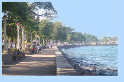
Dumaguete City is a city in the Philippine province of Negros Oriental. It is the capital, principal seaport, and largest city of Negros Oriental. According to the 2000 census, it has a population of 102,265 people. A person from Dumaguete City is called a "Dumagueteño". The city is nicknamed The City of Gentle People.
Dumaguete City is referred to as a university town because of the presence of seven universities and colleges, where students of the province converge to enroll for tertiary education. The city is also a popular educational destination for students of surrounding provinces and cities in Visayas and Mindanao. The city is best known for Silliman University, the first Philippine university outside Manila and the country's first Protestant school. There are also 12 elementary schools and 9 high schools. The city's student population is estimated at 30,000.
The city attracts a considerable number of foreign tourists, particularly Europeans, because of easy ferry access from Cebu City, the availability of beach resorts and dive sites, and the attraction of dolphin and whale watching in nearby Bais Bay.
Feel free to contact us if you have any proposals concerning the duration of the journey, the period of accommodation, the meals, the transportation, the specific thematic programs for groups and other special interest in Negros Oriental.
Email your inquiry to [email protected].
